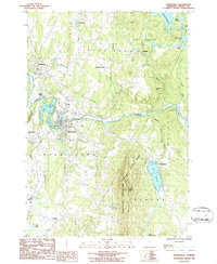
1986 Map of Morrisville
USGS Topo · Published 1986About this map
The Lamoille River cuts a deep path through north-central Vermont, anchoring a landscape defined by the Worcester Mountains and the busy village of Morrisville. In the mid-1980s, this area maintained a mix of rural industry and growing recreation, evident in the Sand & Gravel Pit near Garfield and the sprawling Elmore State Park surrounding Lake Elmore. The mapping shows the transition of local landmarks, from the established seat at Hyde Park to leisure sites like the Drive-in Theater and Golf Course. Water remains a central theme for the region, with the Green River Res and Lake Lamoille providing power and utility, while smaller features like Zack Woods Pd and Terrill Gorge indicate the complex drainage of the surrounding hills. This survey records the layout of local roads and family-named locales like Cleveland Corners before the further modernization of the late 20th century.
Find a feature on this map
44 named features on this map. Tap any name to fly to it.
Don’t see what you’re looking for? This feature index may not catch every label — zoom into the map to look around manually.
Map Details
Editions of this 1986 Morrisville Map
This is the sole edition of this map. No revisions or reprints were ever made.
Other maps of this area

1919 · Montpelier
USGS Topo · 1:62,500

1921 · Montpelier
USGS Topo · 1:62,500

1927 · Hyde Park
USGS Topo · 1:48,000

1928 · Hardwick
USGS Topo · 1:62,500

1930 · Hyde Park
USGS Topo · 1:62,500

1934 · Hardwick
USGS Topo · 1:48,000

1938 · Hardwick
USGS Topo · 1:62,500

1939 · Plainfield
USGS Topo · 1:48,000

1940 · Plainfield
USGS Topo · 1:62,500

1943 · Plainfield
USGS Topo · 1:62,500