Loading...
Loading map...1916 Map of Morrow
USGS Topo · Published 1943About this map
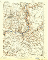
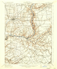
The Little Miami River carves a deep valley through this Warren County landscape, serving as the primary corridor for commerce and travel in the early twentieth century. The town of Morrow sits at a strategic bend in the river, where the Pennsylvania RR and other lines created a vital rail junction. To the west, Lebanon appears as a significant civic hub, noted for the County Infirmary and the Childrens Home on its outskirts.
Find a feature on this map
95 named features on this map. Tap any name to fly to it.
Don’t see what you’re looking for? This feature index may not catch every label — zoom into the map to look around manually.
Map Details
Date Portrayed1916
Date Published1943
PublisherU.S. Geological Survey
Map TypeTopographic
Scale1:62,500
Physical Dimensions16 x 19.7 inches
Editions of this 1916 Morrow Map
2 editions found
Historical Maps of Lebanon Through Time

Featured Locations
Source Details
SourceU.S. Geological Survey
CopyrightPublic Domain