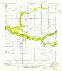
1954 Map of Morse
USGS Topo · Published 1954About this map
Bayou Queue de Tortue carves a broad, marshy path through the heart of the Acadiana prairie, forming a natural boundary between Acadia Parish and Vermilion Parish. This landscape is defined by the early development of irrigation and transport, where the Southern Pacific railroad connects small rural stops like Haire Sta and Mulvey to larger settlements. The map illustrates a highly engineered water system essential for rice cultivation, featuring the Ferre Canal, Avrico Canal, and a prominent Pump House that sustained the local agricultural economy. Settlements such as Morse and Gueydan anchor the region, while smaller hamlets like Lyons Point and Wright highlight the dispersed nature of these coastal prairie communities in the mid-20th century.
Find a feature on this map
16 named features on this map. Tap any name to fly to it.
Don’t see what you’re looking for? This feature index may not catch every label — zoom into the map to look around manually.
Map Details
Editions of this 1954 Morse Map
This is the sole edition of this map. No revisions or reprints were ever made.
Other maps of this area

1946 · Morse
USGS Topo · 1:31,680

1946 · Schooner Bayou NE
USGS Topo · 1:31,680

1946 · Schooner Bayou NW
USGS Topo · 1:31,680

1946 · Mermentau
USGS Topo · 1:31,680

1946 · Kaplan
USGS Topo · 1:31,680

1946 · Rayne
USGS Topo · 1:31,680

1949 · Gueydan
USGS Topo · 1:31,680

1949 · Estherwood
USGS Topo · 1:31,680

1952 · Lake Charles
USGS Topo · 1:250,000
1954 · Schooner Bayou NW
USGS Topo · 1:31,680