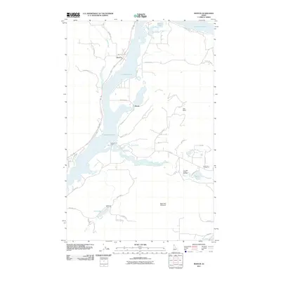
2011 Map of Morton
USGS Topo · Published 2011About this map
Lake Pend Oreille dominates this Bonner County landscape, where the settlements of Morton and Wrencoe sit along the western shoreline. The intricate hydrography of the region is evident in the network of smaller water bodies and drainage systems, including Muskrat Lake, Little Lake, and the winding Cocolalla Creek. This 2011 survey details a mix of established recreation and natural resource management, from the Round Lake Campground to the Cocolalla Creek Fish Weir near Round Lake.
Find a feature on this map
44 named features on this map. Tap any name to fly to it.
Don’t see what you’re looking for? This feature index may not catch every label — zoom into the map to look around manually.
Map Details
Editions of this 2011 Morton Map
This is the sole edition of this map. No revisions or reprints were ever made.
Other maps of this area

1901 · Sandpoint
USGS Topo · 1:125,000

1911 · Priest Lake
USGS Topo · 1:250,000

1911 · Sandpoint
USGS Topo · 1:125,000

1913 · Priest Lake
USGS Topo · 1:250,000

1958 · Sandpoint
USGS Topo · 1:250,000

1963 · Sandpoint
USGS Topo · 1:250,000

1967 · Prater Mtn
USGS Topo · 1:24,000
1968 · Cocolalla
USGS Topo · 1:24,000
1968 · Happy Fork Gap
USGS Topo · 1:24,000
1968 · Morton
USGS Topo · 1:24,000