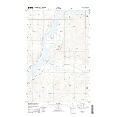
2013 Map of Morton
USGS Topo · Published 2013About this map
Lake Pend Oreille dominates the western landscape of this Idaho quadrangle, defining the shoreline where settlements like Wrencoe and Morton were established. The heavy transport corridor of the BNSF Railway follows the lake's eastern edge, providing a vital rail link through the timbered terrain. This modern survey illustrates the balance between recreation and rural industry, highlighting the Morton Slough Access and Beaux Ranch Field Airport as key local infrastructure.
Find a feature on this map
71 named features on this map. Tap any name to fly to it.
Don’t see what you’re looking for? This feature index may not catch every label — zoom into the map to look around manually.
Map Details
Editions of this 2013 Morton Map
This is the sole edition of this map. No revisions or reprints were ever made.
Other maps of this area

1901 · Sandpoint
USGS Topo · 1:125,000

1911 · Priest Lake
USGS Topo · 1:250,000

1911 · Sandpoint
USGS Topo · 1:125,000

1913 · Priest Lake
USGS Topo · 1:250,000

1958 · Sandpoint
USGS Topo · 1:250,000

1963 · Sandpoint
USGS Topo · 1:250,000

1967 · Prater Mtn
USGS Topo · 1:24,000
1968 · Cocolalla
USGS Topo · 1:24,000
1968 · Happy Fork Gap
USGS Topo · 1:24,000
1968 · Morton
USGS Topo · 1:24,000