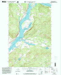
1996 Map of Morton
USGS Topo · Published 1999About this map
The Pend Oreille River dictates the landscape of this Idaho panhandle region, winding through the Kaniksu National Forest north of the Cocolalla Lake area. In the late twentieth century, the small settlements of Morton and Wrencoe remained the primary human outposts along the riverbanks, surrounded by a complex system of waterways and inlets. The presence of Morton Slough and Morton Slough Access indicates a shoreline preserved for recreation and habitat, supported by the neighboring Game Management Area.
Find a feature on this map
25 named features on this map. Tap any name to fly to it.
Don’t see what you’re looking for? This feature index may not catch every label — zoom into the map to look around manually.
Map Details
Editions of this 1996 Morton Map
This is the sole edition of this map. No revisions or reprints were ever made.
Other maps of this area

1901 · Sandpoint
USGS Topo · 1:125,000

1911 · Priest Lake
USGS Topo · 1:250,000

1911 · Sandpoint
USGS Topo · 1:125,000

1913 · Priest Lake
USGS Topo · 1:250,000

1958 · Sandpoint
USGS Topo · 1:250,000

1963 · Sandpoint
USGS Topo · 1:250,000

1967 · Prater Mtn
USGS Topo · 1:24,000
1968 · Cocolalla
USGS Topo · 1:24,000
1968 · Happy Fork Gap
USGS Topo · 1:24,000
1968 · Morton
USGS Topo · 1:24,000