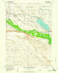
1959 Map of Morton
USGS Topo · Published 1961About this map
The Wind River winds through this Central Wyoming landscape, defining the boundary between the Wind River Indian Reservation and the extensive Riverton Reclamation Withdrawal Area. This era reveals an intricate network of irrigation infrastructure designed to transform the arid Mexican Flat and Kinnear Valley, including the Wyoming Canal and its associated siphons and flumes. The massive Pilot Butte Reservoir dominates the mid-section, supported by the Pilot Butte Power Plant and a series of spillways and wasteways. Evidence of local industry and early settlement is scattered across the terrain, from the Kinnear Mine and a local Oil Field to small family landmarks like Hurtado Cem and Chavez Cem. The topography transitions from the alluvial flats near the river to the higher elevations of Bighorn and Bighorn Butte in the south.
Find a feature on this map
39 named features on this map. Tap any name to fly to it.
Don’t see what you’re looking for? This feature index may not catch every label — zoom into the map to look around manually.
Map Details
Editions of this 1959 Morton Map
3 editions found
Other maps of this area

1950 · Pavillion
USGS Topo · 1:24,000

1950 · Pavillion Butte
USGS Topo · 1:24,000

1951 · Lookout Butte SW
USGS Topo · 1:24,000

1951 · Mule Butte
USGS Topo · 1:24,000

1951 · Morton
USGS Topo · 1:24,000

1951 · Fort Washakie
USGS Topo · 1:24,000

1951 · Lookout Butte
USGS Topo · 1:24,000

1951 · Argo Butte
USGS Topo · 1:24,000

1951 · Ethete
USGS Topo · 1:24,000

1955 · Thermopolis
USGS Topo · 1:250,000