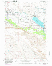
1959 Map of Morton
USGS Topo · Published 1980About this map
The Riverton Reclamation Area dominates this landscape, showing a sophisticated mid-century irrigation network of the Wyoming Canal and Pilot Canal transforming the arid Mexican Flat. Centered on the community of Morton, the map captures the industrial and agricultural development along the Wind River, including the Pilot Butte Power Plant and the expansive Pilot Butte Reservoir. This era of growth is balanced by legacy landmarks like the Mead Mine and Kinnear Mine, as well as an active Oil Field with its associated Pump Houses.
Find a feature on this map
36 named features on this map. Tap any name to fly to it.
Don’t see what you’re looking for? This feature index may not catch every label — zoom into the map to look around manually.
Map Details
Editions of this 1959 Morton Map
3 editions found
Other maps of this area

1950 · Pavillion
USGS Topo · 1:24,000

1950 · Pavillion Butte
USGS Topo · 1:24,000

1951 · Lookout Butte SW
USGS Topo · 1:24,000

1951 · Mule Butte
USGS Topo · 1:24,000

1951 · Morton
USGS Topo · 1:24,000

1951 · Fort Washakie
USGS Topo · 1:24,000

1951 · Lookout Butte
USGS Topo · 1:24,000

1951 · Argo Butte
USGS Topo · 1:24,000

1951 · Ethete
USGS Topo · 1:24,000

1955 · Thermopolis
USGS Topo · 1:250,000