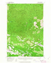
1957 Map of Morton
USGS Topo · Published 1963About this map
Morton and the surrounding Lewis County backcountry are defined by the timber industry and the Cowlitz River during the late 1950s. The settlement of Riffe and nearby Ajlune are documented here alongside several small schools and community landmarks like Harmony Ch and the High Sch in Morton. The landscape is a complex network of drainages including Winston Creek and the Tilton River, which navigate between prominent elevations such as Huckleberry Mtn and Stahl Mtn. The Gifford Pinchot National Forest encompasses much of the northern terrain, where fire management is evidenced by Lookout Peak and other observation points. Industrial activity is visible through labeled logging operations and several Gravel Pits, illustrating the era's reliance on the forest and river systems for economic sustainment prior to significant modern hydrological changes in the Cowlitz valley.
Find a feature on this map
88 named features on this map. Tap any name to fly to it.
Don’t see what you’re looking for? This feature index may not catch every label — zoom into the map to look around manually.
Map Details
Editions of this 1957 Morton Map
3 editions found

Other maps of this area

1916 · Chehalis
USGS Topo · 1:125,000

1919 · Mount St Helens
USGS Topo · 1:125,000

1937 · Eatonville
USGS Topo · 1:125,000

1941 · Tanwax Lake
USGS Topo · 1:62,500

1942 · Toutle
USGS Topo · 1:62,500

1943 · Willapa
USGS Topo · 1:62,500

1944 · Yelm
USGS Topo · 1:62,500

1944 · Ohop Valley
USGS Topo · 1:62,500

1949 · Ohop Valley
USGS Topo · 1:62,500

1949 · Yelm
USGS Topo · 1:62,500