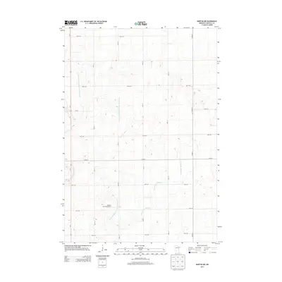
2013 Map of Morton NW
USGS Topo · Published 2013About this map
Agricultural drainage and the geometric precision of the Jeffersonian grid define this Renville County landscape in the early 21st century. The map reveals an intricate network of man-made waterways designed to manage the prairie hydrology, including the extensive County Ditch Number One Hundred Twentyfour, County Ditch Number One Hundred Fortyfour, and Ditch Number Eightyfive-a. These engineered channels run parallel to or intersect a strictly regulated road system, where thoroughfares like 360th St and 740th Ave facilitate the movement of modern industrial farming.
Find a feature on this map
20 named features on this map. Tap any name to fly to it.
Don’t see what you’re looking for? This feature index may not catch every label — zoom into the map to look around manually.
Map Details
Editions of this 2013 Morton NW Map
This is the sole edition of this map. No revisions or reprints were ever made.
Other maps of this area

1952 · Morton
USGS Topo · 1:62,500

1952 · Redwood Falls
USGS Topo · 1:62,500

1953 · New Ulm
USGS Topo · 1:250,000

1957 · New Ulm
USGS Topo · 1:250,000

1957 · Olivia
USGS Topo · 1:62,500

1958 · New Ulm
USGS Topo · 1:250,000

1965 · Danube
USGS Topo · 1:24,000

1967 · New Ulm
USGS Topo · 1:250,000
1982 · Olivia SE
USGS Topo · 1:24,000
1982 · Redwood Falls
USGS Topo · 1:24,000