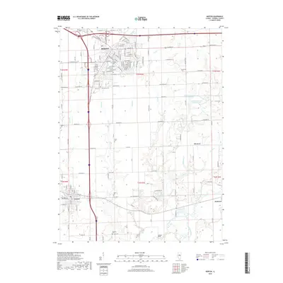
2018 Map of Morton
USGS Topo · Published 2018About this map
Morton stands as a significant hub of suburban and agricultural life in central Illinois, anchored by its extensive street grid and proximity to the Mackinaw River. The landscape is defined by the drainage patterns of numerous creeks including Prairie Creek, Bull Run, and Deer Creek, which carve through the till plains toward the river in the southeast. This 2018 survey reveals a territory dense with genealogical markers, from the Old Apostolic Cemetery and Apostolic Christian Cemetery to outlying family-named sites like the Buckeye Cemetery and Winzeler Cemetery. Smaller settlements such as Allentown and the northern edge of Tremont provide a clear view of the transition from residential neighborhoods to the broad farming tracts of Tazewell County. Recreational areas like Wilman Sportsman Club East Lake and landmarks such as the Vaughter Bridge illustrate the community's relationship with its local water resources.
Find a feature on this map
83 named features on this map. Tap any name to fly to it.
Don’t see what you’re looking for? This feature index may not catch every label — zoom into the map to look around manually.
Map Details
Editions of this 2018 Morton Map
This is the sole edition of this map. No revisions or reprints were ever made.
Other maps of this area

1905 · Peoria
USGS Topo · 1:62,500

1927 · Peoria
USGS Topo · 1:62,500

1928 · Mackinaw
USGS Topo · 1:62,500

1932 · Mackinaw
USGS Topo · 1:62,500

1942 · Delavan
USGS Topo · 1:62,500

1949 · Peoria East
USGS Topo · 1:24,000
1950 · Peoria East
USGS Topo · 1:24,000

1951 · Minier
USGS Topo · 1:62,500

1958 · Peoria
USGS Topo · 1:250,000

1960 · Marquette Heights
USGS Topo · 1:24,000