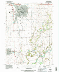
1995 Map of Morton
USGS Topo · Published 1996About this map
Morton appears here as a primary regional hub during the mid-1990s, defined by its organized residential grid and expanding municipal footprint. The map reveals a community centered around civic anchors like City Hall, Town Hall, and several local schools, including Ward Grundy Sch and Jefferson Sch. The surrounding landscape transitions into rural acreage, where small settlements like Allentown and the northern edge of Tremont persist alongside the Mackinaw River. This river corridor, protected in parts by a Levee, serves as a stark natural contrast to the industrial and infrastructure-heavy western border. Local history is deeply embedded in the rural landscape, preserved through numerous family and community burial grounds such as Buckeye Cem and Winzeler Cem. The presence of several Gravel Pits near the river suggests the ongoing importance of local mineral extraction to the area's economy during this era.
Find a feature on this map
48 named features on this map. Tap any name to fly to it.
Don’t see what you’re looking for? This feature index may not catch every label — zoom into the map to look around manually.
Map Details
Editions of this 1995 Morton Map
This is the sole edition of this map. No revisions or reprints were ever made.
Other maps of this area

1905 · Peoria
USGS Topo · 1:62,500

1927 · Peoria
USGS Topo · 1:62,500

1928 · Mackinaw
USGS Topo · 1:62,500

1932 · Mackinaw
USGS Topo · 1:62,500

1942 · Delavan
USGS Topo · 1:62,500

1949 · Peoria East
USGS Topo · 1:24,000
1950 · Peoria East
USGS Topo · 1:24,000

1951 · Minier
USGS Topo · 1:62,500

1958 · Peoria
USGS Topo · 1:250,000

1960 · Marquette Heights
USGS Topo · 1:24,000