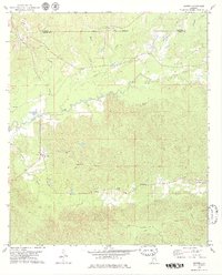
1978 Map of Morvin
USGS Topo · Published 1979About this map
The Indian Treaty Boundary cuts across the northern landscape of this region, separating the borders of Marengo and Clarke Counties near Holtamville. This area is defined by a network of rural settlements and small country churches, including Walnut Grove Ch in Morvin and Creels Ch further east. The topography is deeply carved by watercourses like Bashi Creek and Tallahatta Creek, which drain the timbered hillsides. Further south, the map reveals localized community hubs such as Opine and Tallahatta Springs, where a Community Hall and the Bashan Ch serve the local residents. Family history is anchored by sites like Campbell Cem and Lucker Cem, while the presence of Gravel Pits in the northwest suggests the small-scale extractive industries common to the Alabama coastal plain during the mid-1970s.
Find a feature on this map
34 named features on this map. Tap any name to fly to it.
Don’t see what you’re looking for? This feature index may not catch every label — zoom into the map to look around manually.
Map Details
Editions of this 1978 Morvin Map
2 editions found
Other maps of this area

1953 · Montgomery
USGS Topo · 1:250,000

1953 · Andalusia
USGS Topo · 1:250,000

1953 · Hattiesburg
USGS Topo · 1:250,000

1953 · Meridian
USGS Topo · 1:250,000

1956 · Montgomery
USGS Topo · 1:250,000

1957 · Meridian
USGS Topo · 1:250,000

1957 · Montgomery
USGS Topo · 1:250,000

1957 · Andalusia
USGS Topo · 1:250,000

1958 · Hattiesburg
USGS Topo · 1:250,000

1965 · Meridian
USGS Topo · 1:250,000