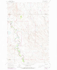
1962 Map of Mosby SE
USGS Topo · Published 1980About this map
The Musselshell River winds through a complex network of dry coulees and creek beds in this eastern Montana landscape, reflecting the remote ranching character of the region in the early 1960s. The river's serpentine course serves as a focal point for the surrounding terrain, which is defined by significant drainage features such as Nineteen Coulee, Youderian Coulee, and Turner Coulee. An interpretive look at the map reveals the meeting point of four distinct counties—Garfield, Rosebud, Petroleum, and Musselshell—at a time when land division was primarily marked by natural landmarks and fence lines.
Find a feature on this map
11 named features on this map. Tap any name to fly to it.
Don’t see what you’re looking for? This feature index may not catch every label — zoom into the map to look around manually.
Map Details
Editions of this 1962 Mosby SE Map
2 editions found
Other maps of this area

1954 · Forsyth
USGS Topo · 1:250,000

1957 · Forsyth
USGS Topo · 1:250,000

1958 · Forsyth
USGS Topo · 1:250,000

1962 · Mosby
USGS Topo · 1:24,000

1962 · Melstone NE
USGS Topo · 1:24,000

1962 · Maxwell Ranch
USGS Topo · 1:24,000

1962 · Melstone NW
USGS Topo · 1:24,000

1962 · Kincheloe Ranch
USGS Topo · 1:24,000

1962 · Mosby SE
USGS Topo · 1:24,000

1962 · Grebe Ranch
USGS Topo · 1:24,000