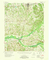
1968 Map of Moscow
USGS Topo · Published 1968About this map
Somerville stands as the primary seat of activity in this 1960s survey of southern Fayette County, situated at the junction of several regional routes north of the Wolf River. The landscape is defined by the winding paths of the Loosahatchie River and its accompanying Canal, which share the terrain with a dense network of country churches and small rural schools. In the southern portion of the sheet, the Southern railroad connects the riverside settlements of Moscow and LaGrange, providing a vital transit link across the West Tennessee bottomlands. The presence of the Old State Line near the southern border highlights the historic boundary between Tennessee and Mississippi, while family names like Hays Crossing and Pattersonville underscore the area's agricultural and social heritage. Numerous local landmarks, including the County Training Sch and Spring Hill Bluff, offer a detailed view of the community infrastructure during this era.
Find a feature on this map
115 named features on this map. Tap any name to fly to it.
Don’t see what you’re looking for? This feature index may not catch every label — zoom into the map to look around manually.
Map Details
Editions of this 1968 Moscow Map
This is the sole edition of this map. No revisions or reprints were ever made.
Other maps of this area

1943 · Collierville
USGS Topo · 1:62,500

1948 · Byhalia
USGS Topo · 1:62,500

1949 · Moscow
USGS Topo · 1:62,500

1950 · Ashland
USGS Topo · 1:62,500

1950 · Grand Junction
USGS Topo · 1:24,000

1951 · Hickory Valley
USGS Topo · 1:24,000

1951 · Grand Junction
USGS Topo · 1:24,000

1952 · Lambert
USGS Topo · 1:24,000

1952 · Laconia
USGS Topo · 1:24,000

1952 · Stanton
USGS Topo · 1:62,500