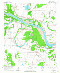
1964 Map of Moscow
USGS Topo · Published 1965About this map
The Arkansas River dictates the landscape of this delta region, where meandering oxbows and bayous define the boundaries of Richland. The settlement at Moscow serves as a local hub along the Missouri Pacific railroad, supported by smaller communities like Linwood and New Gascony. This area preserves a dense record of early community life through its numerous burial grounds and congregations, including New Gascony Cem, St Peters Cem, and Mulberry Grove Ch.
Find a feature on this map
38 named features on this map. Tap any name to fly to it.
Don’t see what you’re looking for? This feature index may not catch every label — zoom into the map to look around manually.
Map Details
Editions of this 1964 Moscow Map
2 editions found
Other maps of this area

1935 · Altheimer
USGS Topo · 1:62,500

1935 · Varner
USGS Topo · 1:62,500

1935 · Noble Lake
USGS Topo · 1:62,500

1941 · Goldman
USGS Topo · 1:62,500

1948 · Helena
USGS Topo · 1:250,000

1950 · Helena
USGS Topo · 1:250,000

1955 · Helena
USGS Topo · 1:250,000

1959 · Helena
USGS Topo · 1:250,000

1960 · Helena
USGS Topo · 1:250,000
1964 · Tarry
USGS Topo · 1:24,000