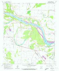
1964 Map of Moscow
USGS Topo · Published 1973About this map
The Arkansas River dominates this mid-century landscape of Jefferson County, where the river's shifting path is marked by ancient curves and numerous bayous. Along the southern bank, the Missouri Pacific railroad anchors a string of small communities from Linwood down to Moscow. The map reveals a high concentration of family and community burial grounds, including Hunters Cem, Cherry Hill Cem, and Blackman Cem, which reflect the area's deep-rooted settlement history.
Find a feature on this map
48 named features on this map. Tap any name to fly to it.
Don’t see what you’re looking for? This feature index may not catch every label — zoom into the map to look around manually.
Map Details
Editions of this 1964 Moscow Map
2 editions found
Other maps of this area

1935 · Altheimer
USGS Topo · 1:62,500

1935 · Varner
USGS Topo · 1:62,500

1935 · Noble Lake
USGS Topo · 1:62,500

1941 · Goldman
USGS Topo · 1:62,500

1948 · Helena
USGS Topo · 1:250,000

1950 · Helena
USGS Topo · 1:250,000

1955 · Helena
USGS Topo · 1:250,000

1959 · Helena
USGS Topo · 1:250,000

1960 · Helena
USGS Topo · 1:250,000
1964 · Tarry
USGS Topo · 1:24,000