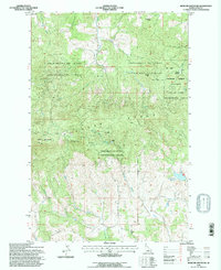
1994 Map of Moscow Mountain
USGS Topo · Published 1997About this map
University of Idaho Experimental Forest lands dominate this mid-1990s look at the high country of the Palouse Range. The topography is anchored by the summit of Moscow Mountain, where the East Moscow Lookout stands watch over a landscape defined by timber management and recreational use. The map illustrates the specialized land use of the era, from the winter slopes of the Tamarack Ski Area to the remote St Joe National Forest acreage. To the south, the terrain descends toward Randall Flat and the headwaters of W Fk Little Bear Creek. Along the lower elevations, the Beulah Cem and several water management sites like the Village of Troy Reservoir reflect the intersection of the working forest with local community infrastructure.
Find a feature on this map
24 named features on this map. Tap any name to fly to it.
Don’t see what you’re looking for? This feature index may not catch every label — zoom into the map to look around manually.
Map Details
Editions of this 1994 Moscow Mountain Map
This is the sole edition of this map. No revisions or reprints were ever made.
Other maps of this area

1955 · Pullman
USGS Topo · 1:250,000

1958 · Pullman
USGS Topo · 1:250,000

1960 · Troy
USGS Topo · 1:24,000

1960 · Robinson Lake
USGS Topo · 1:24,000

1960 · Moscow Mtn
USGS Topo · 1:24,000

1960 · Moscow East
USGS Topo · 1:24,000

1960 · Potlatch
USGS Topo · 1:62,500

1961 · Deary
USGS Topo · 1:62,500

1961 · Kendrick
USGS Topo · 1:62,500

1961 · Moscow
USGS Topo · 1:62,500