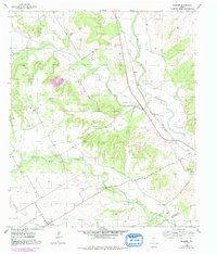
1956 Map of Mosheim
USGS Topo · Published 1991About this map
The North Bosque River winds through this central Texas landscape, marking the boundary between Bosque County and McLennan County. This mid-century survey captures a rural environment defined by creek drainages and small community hubs like Mosheim, where local roads converge near the southern edge. The terrain is notably dissected by Neils Creek and Shoal Creek, with elevations shifting between creek bottoms and uplands where a Stone Quarry and Caliche Pit indicate local mineral extraction. Genealogists will find a significant distribution of family-named burial sites across the hills, including Terrell Cemetery, Kanz Cem, and Barton Cem. Industrial infrastructure is represented by a major Pipeline and the Pendell Pumping Sta located near the settlement of Pendell, illustrating the intersection of traditional ranching land with growing mid-century utility networks.
Find a feature on this map
22 named features on this map. Tap any name to fly to it.
Don’t see what you’re looking for? This feature index may not catch every label — zoom into the map to look around manually.
Map Details
Editions of this 1956 Mosheim Map
2 editions found
Other maps of this area

1888 · Meridian
USGS Topo · 1:125,000

1892 · Waco
USGS Topo · 1:125,000

1894 · Meridian
USGS Topo · 1:125,000

1920 · Waco
USGS Topo · 1:125,000

1931 · Whitney
USGS Topo · 1:62,500

1931 · Valley Mills
USGS Topo · 1:62,500

1954 · Waco
USGS Topo · 1:250,000

1955 · Waco
USGS Topo · 1:250,000

1955 · Clifton
USGS Topo · 1:24,000
1955 · Turnersville
USGS Topo · 1:24,000