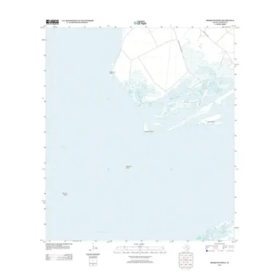
2013 Map of Mosquito Point
USGS Topo · Published 2013About this map
San Antonio Bay dominates this coastal landscape, where the shifting margins of the Texas Gulf Coast define the geography of Calhoun County. The map details a complex network of marshes and open water, notably around Mosquito Point and the adjacent wetlands. Small landforms like Turnstake Island, Grass Island, and the avian-named Little Bird Island and Big Bird Island serve as critical reference points for navigating these shallow waters. Human activity in this sensitive environment is represented by a few key access points, including Welder Flats Rd and Welder Cliburn Ranch Rd, which lead toward the shoreline. To the south, the Panther Reef Cut provides a clear channel through the submerged reefs, illustrating the ongoing management of coastal waterways for local transit and fishing.
Find a feature on this map
9 named features on this map. Tap any name to fly to it.
Don’t see what you’re looking for? This feature index may not catch every label — zoom into the map to look around manually.
Map Details
Editions of this 2013 Mosquito Point Map
This is the sole edition of this map. No revisions or reprints were ever made.
Other maps of this area

1952 · Mosquito Point
USGS Topo · 1:24,000

1952 · Long Island
USGS Topo · 1:24,000

1952 · Mesquite Bay
USGS Topo · 1:24,000

1952 · Tivoli SE
USGS Topo · 1:24,000

1952 · Seadrift NE
USGS Topo · 1:24,000

1952 · Panther Point
USGS Topo · 1:24,000

1952 · Austwell
USGS Topo · 1:24,000

1952 · Seadrift
USGS Topo · 1:24,000
1952 · Panther Point NE
USGS Topo · 1:24,000

1953 · Beeville
USGS Topo · 1:250,000