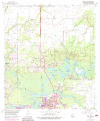
1955 Map of Moss Bluff
USGS Topo · Published 1984About this map
The confluence of the Calcasieu River and English Bayou dominates this landscape, where intricate waterways like Bird Island Bay and Watermelon Bay cut through the wetlands north of Lake Charles. The mid-century development of Moss Bluff is visible, with its school and nearby settlements such as Belfield and Ararat oriented along the Southern Pacific railroad line. This survey, photorevised in the 1970s, captures the transition from rural swamp and bayou country into an expanding suburban and industrial fringe. For genealogists, the map is remarkably dense with family-named landmarks and cemeteries, including the Goos Cem, Bagdad Cem, and Birdsnest Cem. Large tracts of land remain preserved within Sam Houston State Park, while the urban reach of Goosport pushes north toward Bridge Junction.
Find a feature on this map
53 named features on this map. Tap any name to fly to it.
Don’t see what you’re looking for? This feature index may not catch every label — zoom into the map to look around manually.
Map Details
Editions of this 1955 Moss Bluff Map
4 editions found
Other maps of this area

1932 · Lake Charles NE
USGS Topo · 1:31,680

1932 · Lake Charles NW
USGS Topo · 1:31,680

1935 · Buhler
USGS Topo · 1:31,680

1935 · Moss Bluff
USGS Topo · 1:31,680

1935 · Gordon
USGS Topo · 1:31,680

1935 · Gaytine
USGS Topo · 1:31,680

1942 · Lake Charles
USGS Topo · 1:62,500

1947 · Gaytine
USGS Topo · 1:31,680

1947 · Moss Bluff
USGS Topo · 1:31,680

1947 · Hecker
USGS Topo · 1:31,680