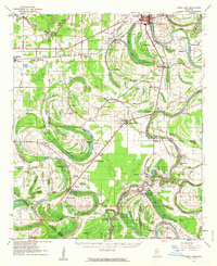
1961 Map of Mossy Lake
USGS Topo · Published 1963About this map
Itta Bena and Moorhead anchor this 1961 survey of the Mississippi Delta, a landscape defined by its intricate river systems and fertile floodplains. The Yazoo River and Quiver River frame a region crisscrossed by bayous and oxbow lakes, such as Mossy Lake and Bee Lake. The rural economy of the era is evident in the dense network of small communities and family landmarks, including Colony Town, Sheppardtown, and Swiftown. The presence of numerous churches like Zion Rock Ch and Cypress Grove Ch, alongside scattered cemeteries such as McIntyre Cem, provides a detailed record of local genealogy and settlement patterns.
Find a feature on this map
114 named features on this map. Tap any name to fly to it.
Don’t see what you’re looking for? This feature index may not catch every label — zoom into the map to look around manually.
Map Details
Editions of this 1961 Mossy Lake Map
3 editions found

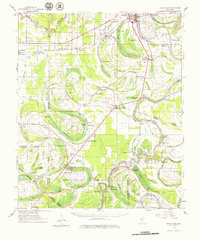
Other maps of this area

1931 · Schlater
USGS Topo · 1:48,000

1934 · Cleveland
USGS Topo · 1:62,500

1934 · Schlater
USGS Topo · 1:62,500

1936 · Greenwood
USGS Topo · 1:62,500

1939 · Schlater
USGS Topo · 1:62,500

1940 · Seven Pines
USGS Topo · 1:62,500

1940 · Auter
USGS Topo · 1:62,500

1940 · Baird
USGS Topo · 1:62,500

1940 · Lexington
USGS Topo · 1:62,500

1940 · Greenwood
USGS Topo · 1:62,500