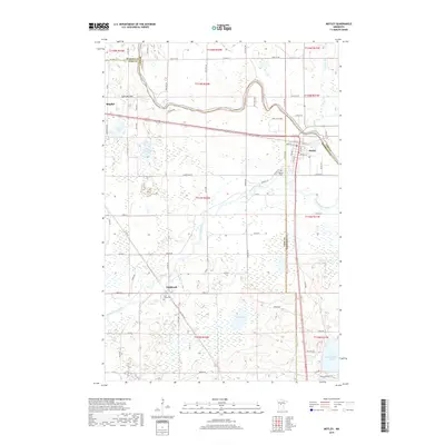
2019 Map of Motley
USGS Topo · Published 2019About this map
The confluence of the Crow Wing River and the Long Prairie River defines this landscape in central Minnesota, where the borders of Cass, Todd, and Morrison counties meet. The settlement of Motley serves as a local hub at this junction, while the Burlington Northern Santa Fe railroad line cuts a straight path across the northern reaches toward Staples. Further south, the rural character of the region is evident near Philbrook, where the landscape transitions into a mosaic of wetlands and small lakes like Shamineau Lake and Mud Lake. Genealogists may find value in the locations of Motley Cem and Saint James Cem, the latter situated near the winding Fish Trap Creek. The presence of the Lois Lake Bed suggests a shifting hydrology in a region dominated by glacial plains and river valleys.
Find a feature on this map
75 named features on this map. Tap any name to fly to it.
Don’t see what you’re looking for? This feature index may not catch every label — zoom into the map to look around manually.
Map Details
Editions of this 2019 Motley Map
This is the sole edition of this map. No revisions or reprints were ever made.
Other maps of this area

1948 · Cushing
USGS Topo · 1:62,500

1950 · Cushing
USGS Topo · 1:62,500

1953 · Brainerd
USGS Topo · 1:250,000

1957 · Brainerd
USGS Topo · 1:250,000

1958 · Brainerd
USGS Topo · 1:250,000
1963 · Motley SE
USGS Topo · 1:24,000

1963 · Motley
USGS Topo · 1:24,000

1965 · Brainerd
USGS Topo · 1:250,000

1966 · Staples NE
USGS Topo · 1:24,000
1966 · Casino
USGS Topo · 1:24,000