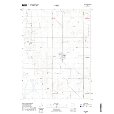
2018 Map of Moulton
USGS Topo · Published 2018About this map
Moulton serves as the primary hub of this southern Iowa landscape, situated at the intersection of local routes in Appanoose County. The town's grid is well-defined by streets such as W Broadway St and W 5th St, reflecting its historical development as a regional center. To the north, the small community of Orleans sits near the headwaters of S Fox Cr, while Dean occupies the southern reach of the quadrangle near the Chariton River. The terrain is deeply etched by a network of waterways including N Fabius River and Carter Cr, creating a rolling topography that has influenced the placement of numerous family and community burial grounds. Genealogists will find a high density of these sites, including Hardin Cem, Sunnyview Cem, and the uniquely neighboring Otterbien Cem and Otterbein South Cem in the west, which preserve the names of the area's early settlers and their distinct family lineages.
Find a feature on this map
84 named features on this map. Tap any name to fly to it.
Don’t see what you’re looking for? This feature index may not catch every label — zoom into the map to look around manually.
Map Details
Editions of this 2018 Moulton Map
This is the sole edition of this map. No revisions or reprints were ever made.
Other maps of this area

1939 · Centerville
USGS Topo · 1:62,500

1939 · Mystic
USGS Topo · 1:62,500

1941 · Centerville
USGS Topo · 1:62,500

1942 · Mystic
USGS Topo · 1:62,500

1954 · Centerville
USGS Topo · 1:250,000

1957 · Centerville
USGS Topo · 1:250,000

1958 · Centerville
USGS Topo · 1:250,000

1966 · Hiattsville
USGS Topo · 1:24,000

1968 · Unionville
USGS Topo · 1:24,000
1968 · Paris
USGS Topo · 1:24,000