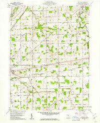
1960 Map of Moulton
USGS Topo · Published 1961About this map
The Miami and Erie Canal (Abandoned) cuts through the western reaches of this Auglaize County landscape, serving as a reminder of an earlier era of Ohio transportation alongside the St Marys River. By the early 1960s, the region had transitioned to a rail-and-road economy, anchored by the New York Chicago and St Louis RR and the New York Central RR. Small rural hubs like Buckland, Glynwood, and Moulton are connected by a grid of section-line roads, many bearing family names such as Brewer Road and Neeley Road.
Find a feature on this map
49 named features on this map. Tap any name to fly to it.
Don’t see what you’re looking for? This feature index may not catch every label — zoom into the map to look around manually.
Map Details
Editions of this 1960 Moulton Map
Other maps of this area

1906 · Lima
USGS Topo · 1:62,500

1909 · Loramie
USGS Topo · 1:62,500

1911 · Loramie
USGS Topo · 1:62,500

1911 · Spencerville
USGS Topo · 1:62,500

1913 · Sidney
USGS Topo · 1:62,500

1944 · Sidney
USGS Topo · 1:62,500

1944 · Loramie
USGS Topo · 1:62,500

1944 · Spencerville
USGS Topo · 1:62,500

1953 · Muncie
USGS Topo · 1:250,000

1956 · Muncie
USGS Topo · 1:250,000