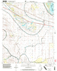
1998 Map of Mound
USGS Topo · Published 2003About this map
The Mississippi River and its intricate network of former channels define the landscape of Madison Parish, Louisiana. This map reveals a terrain heavily influenced by the river's movement, including several oxbow lakes such as Sandbank Lake, Texas Lake, Big Lake, and Long Lake. Ancient history is preserved at the Indian Mounds located near Coleman, while the local social fabric is traced through numerous community sites like St John Ch, Mt Moriah Ch No 2, and Solomon Temple. Settled areas like Thomastown and Mound are situated near Rattlesnake Ridge, suggesting early development was concentrated on the slightly higher ground above the wetlands. Transportation hubs like the Vicksburg Tallulah Regional Airport and several landing strips, such as the Cape Landing Strip, indicate the area's continued reliance on local aviation for reaching these river-adjacent properties.
Find a feature on this map
45 named features on this map. Tap any name to fly to it.
Don’t see what you’re looking for? This feature index may not catch every label — zoom into the map to look around manually.
Map Details
Editions of this 1998 Mound Map
This is the sole edition of this map. No revisions or reprints were ever made.
Other maps of this area

1909 · Millikens Bend
USGS Topo · 1:24,000

1909 · Tallulah
USGS Topo · 1:24,000

1909 · Mound
USGS Topo · 1:24,000

1910 · Mound
USGS Topo · 1:31,680

1918 · Vicksburg
USGS Topo · 1:62,500

1939 · Talla Bena
USGS Topo · 1:62,500

1939 · Yokena
USGS Topo · 1:62,500

1941 · Vicksburg
USGS Topo · 1:62,500

1955 · Jackson
USGS Topo · 1:250,000

1961 · Jackson
USGS Topo · 1:250,000