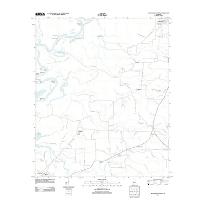
2011 Map of Moundville West
USGS Topo · Published 2011About this map
The Black Warrior River defines the western edge of this landscape, its winding course marked by a series of river bars and shoals including Cleveland Shoals and Hazzards Bar. The river's influence on the local topography is evident in the numerous cutoff lakes and sloughs, such as Keaton Lake and Cypress Cutoff Lake, which pocket the bottomlands. Moving inland, the terrain transitions to a patchwork of small settlements and agricultural crossings. Moundville anchors the northeast corner, while smaller localities like Cypress, Guinea, and Havana Junction are connected by a network of county roads. Genealogists will find significant value in the distribution of rural burial sites across the quadrangle, from the Mileous Chapel Cemetery near Stewart to the Concord Cemetery and Martin Mission Cemetery further east. These sites, often located near local watercourses like Martin Creek and Gabriel Creek, provide a spatial record of family and community history in this portion of Alabama.
Find a feature on this map
85 named features on this map. Tap any name to fly to it.
Don’t see what you’re looking for? This feature index may not catch every label — zoom into the map to look around manually.
Map Details
Editions of this 2011 Moundville West Map
This is the sole edition of this map. No revisions or reprints were ever made.
Other maps of this area

1924 · Tuscaloosa
USGS Topo · 1:62,500

1926 · Tuscaloosa
USGS Topo · 1:62,500

1927 · Eutaw
USGS Topo · 1:48,000

1931 · Eutaw
USGS Topo · 1:62,500

1953 · Montgomery
USGS Topo · 1:250,000

1953 · Birmingham
USGS Topo · 1:250,000

1956 · Birmingham
USGS Topo · 1:250,000

1956 · Montgomery
USGS Topo · 1:250,000

1957 · Birmingham
USGS Topo · 1:250,000

1957 · Montgomery
USGS Topo · 1:250,000