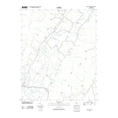
2010 Map of Mount Airy
USGS Topo · Published 2010About this map
The Sequatchie River valley defines this landscape, winding through a corridor of agricultural plots and family-named landmarks. The map documents a dense network of local cemeteries, including Hixson Cemetery, Collier Cemetery, and the Welch Chapel Cemetery, which provide a detailed record of the region’s long-standing families. Transportation patterns are centered on the river's crossings, from the modern Standifer Bridge to older points like Stephen Chapel Ford and Harris Ford. Near the southwestern corner, the Brush Creek Siding sits along the rail line by Big Brush Creek, hinting at the area's industrial transit history. Distinctive topographic features like The Big Flat and Raven Cliff rise above the valley floor, while a web of named roads such as Old York Hwy N and Lower East Valley Rd connect the scattered homesteads and church sites.
Find a feature on this map
81 named features on this map. Tap any name to fly to it.
Don’t see what you’re looking for? This feature index may not catch every label — zoom into the map to look around manually.
Map Details
Editions of this 2010 Mount Airy Map
This is the sole edition of this map. No revisions or reprints were ever made.
Other maps of this area

1888 · Chattanooga
USGS Topo · 1:125,000

1892 · Pikeville
USGS Topo · 1:125,000

1893 · Chattanooga
USGS Topo · 1:125,000

1895 · Pikeville
USGS Topo · 1:125,000

1909 · Sequatchie Valley
USGS Topo · 1:62,500

1910 · Pikeville
USGS Topo · 1:62,500

1935 · Soddy
USGS Topo · 1:24,000

1935 · Brockdell
USGS Topo · 1:24,000

1935 · Brayton
USGS Topo · 1:24,000

1935 · Mount Airy
USGS Topo · 1:24,000