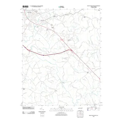
2010 Map of Mount Airy South
USGS Topo · Published 2010About this map
Ararat River and its numerous tributaries, including Lovills Creek, Stoney Creek, and Flat Shoal Creek, carve a detailed drainage pattern through this portion of Surry County. The landscape is defined by a network of small named communities such as Bannertown, Sheltontown, Indian Grove, and Boones Hill that are connected by a dense grid of local roads and larger thoroughfares like South Main Street. The presence of the Mount Airy-Surry County Airport and the expansive Skyline Memorial Garden south of Mount Airy indicates the area's modern infrastructure and community development. Genealogists may find value in the specific locations of Whitakers Chapel Cemetery and the various residential roads like Cook School Rd and Simmons Grove Church Rd, which preserve the names of local families and long-standing institutions within the Piedmont terrain.
Find a feature on this map
89 named features on this map. Tap any name to fly to it.
Don’t see what you’re looking for? This feature index may not catch every label — zoom into the map to look around manually.
Map Details
Editions of this 2010 Mount Airy South Map
This is the sole edition of this map. No revisions or reprints were ever made.
Other maps of this area

1889 · Hillsville
USGS Topo · 1:125,000

1891 · Yadkinville
USGS Topo · 1:125,000

1892 · Hillsville
USGS Topo · 1:125,000

1893 · Yadkinville
USGS Topo · 1:125,000

1896 · Hillsville
USGS Topo · 1:125,000

1928 · Stuart
USGS Topo · 1:48,000

1931 · Stuart
USGS Topo · 1:62,500

1953 · Winston-Salem
USGS Topo · 1:250,000

1955 · Winston-Salem
USGS Topo · 1:250,000

1957 · Mount Airy
USGS Topo · 1:62,500