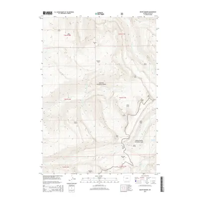
2015 Map of Mount Bannon
USGS Topo · Published 2015About this map
Mt Jedediah Smith and Mt Bannon define the high ridgelines where the Targhee National Forest meets Grand Teton National Park. This 2015 survey details a landscape where water and ice have carved deep drainages, such as Darby Canyon and Death Canyon, leaving behind distinctive geological formations like the Death Canyon Shelf and Fossil Mtn. The hydrology of the Teton Range is clearly delineated, showing the headwaters of the S Fork Teton Cr and Darby Cr flowing westward, while alpine features like Pass Lake and the Forget-me-not Lakes occupy the higher elevations. This map is particularly useful for understanding the trail corridors and passes, such as Fox Creek Pass, that connect these protected wilderness areas. The topography reveals the sharp relief between peaks like Spearhead Peak and the surrounding basins, documenting the primary drainage network of Fox Cr and Roaring Cr as they appeared in the early 21st century.
Find a feature on this map
36 named features on this map. Tap any name to fly to it.
Don’t see what you’re looking for? This feature index may not catch every label — zoom into the map to look around manually.
Map Details
Editions of this 2015 Mount Bannon Map
This is the sole edition of this map. No revisions or reprints were ever made.
Other maps of this area

1899 · Grand Teton
USGS Topo · 1:125,000

1901 · Grand Teton
USGS Topo · 1:125,000

1943 · Driggs
USGS Topo · 1:62,500

1946 · Driggs
USGS Topo · 1:62,500

1955 · Driggs
USGS Topo · 1:250,000

1958 · Driggs
USGS Topo · 1:250,000

1962 · Driggs
USGS Topo · 1:250,000

1965 · Clawson
USGS Topo · 1:24,000
1968 · Granite Basin
USGS Topo · 1:24,000
1968 · Teton Village
USGS Topo · 1:24,000