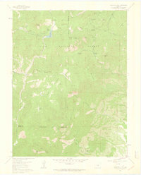
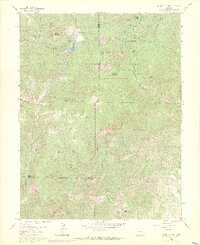
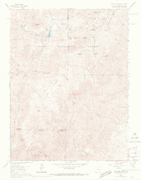
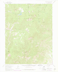
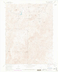
1961 Map of Mount Big Chief
USGS Topo · Published 1963About this map
Mount Big Chief towers over a landscape defined by the drainage divide between Beaver Creek and the southern slopes of Cheyenne Mtn during the early 1960s. This portion of the Pike National Forest shows a transition from high-altitude reservoirs like the Penrose-Rosemont Reservoir to the complex canyon systems of Little Turkey Creek and Red Creek Canyon. The map documents a specific era of mountain recreation and ranching, featuring the Broadmoor Lodge, Emerald Valley Ranch, and the Emerald Valley Boys Camp. The iconic Gold Camp Road snakes through the northern peaks, tracing a path near Rosemont and St Peters Dome. Geologic exploration is evident through various prospects scattered near Sugarloaf Mountain and McKinley Peak, while the southern reaches of the map show the remote Turkey Canyon Ranch and Elk Ranch situated along the rugged watercourses.
Find a feature on this map
43 named features on this map. Tap any name to fly to it.
Don’t see what you’re looking for? This feature index may not catch every label — zoom into the map to look around manually.
Map Details
Editions of this 1961 Mount Big Chief Map
6 editions found

Other maps of this area

1893 · Colorado Springs
USGS Topo · 1:125,000

1894 · Pikes Peak
USGS Topo · 1:125,000

1901 · Pikes Peak
USGS Topo · 1:125,000

1901 · Pikes Peak
USGS Topo · 1:62,500

1909 · Colorado Springs
USGS Topo · 1:125,000

1942 · Colorado Springs
USGS Topo · 1:125,000
1948 · Mount Big Chief
USGS Topo · 1:24,000

1948 · Mount Pittsburg
USGS Topo · 1:24,000

1948 · Timber Mountain
USGS Topo · 1:24,000
1948 · Manitou Springs
USGS Topo · 1:24,000