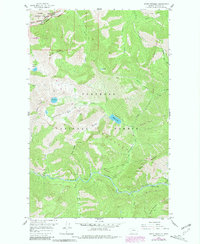
1958 Map of Mount Bradley
USGS Topo · Published 1981About this map
The Middle Fork Flathead River serves as the dominant hydrological feature of this wilderness corridor, carving a deep path between the high peaks of the Flathead National Forest and Glacier National Park. This 1958 survey, updated with late-1970s Forest Service data, documents a landscape managed for conservation and remote backcountry access. Notable high-altitude crossings include Roosevelt Pass and Singleshot Pass in the north, while the southern reaches are marked by the Granite Forest Service Facility near the riverbank. The terrain is characterized by steep ridges like Patrol Ridge and glacial basins such as Tranquil Basin and Giefer Lake. The inclusion of the Great Bear Wilderness boundary reflects the evolving federal land management of the mid-20th century, capturing the area before modern recreational impacts altered these drainage networks.
Find a feature on this map
34 named features on this map. Tap any name to fly to it.
Don’t see what you’re looking for? This feature index may not catch every label — zoom into the map to look around manually.
Map Details
Editions of this 1958 Mount Bradley Map
3 editions found
Other maps of this area

1913 · Marias Pass
USGS Topo · 1:125,000

1914 · Nyack
USGS Topo · 1:125,000

1958 · Red Plume Mountain
USGS Topo · 1:24,000

1958 · Capitol Mountain
USGS Topo · 1:24,000

1958 · Circus Peak
USGS Topo · 1:24,000

1958 · Nimrod
USGS Topo · 1:24,000

1958 · Mount Bradley
USGS Topo · 1:24,000

1958 · Horseshoe Peak
USGS Topo · 1:24,000

1960 · Cut Bank
USGS Topo · 1:250,000

1963 · Cut Bank
USGS Topo · 1:250,000