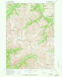
1969 Map of Mount Burwell
USGS Topo · Published 1971About this map
Absaroka Range peaks dominate this high-altitude landscape, where the Shoshone National Forest and Absaroka Wilderness protect a network of headwaters and mountain passes. The terrain is defined by dramatic elevation changes, centered on the Mount Burwell summit and the nearby Burwell Pass. Waterways like the Greybull River and Wiggins Fork carve deep valleys through the mountains, serving as primary corridors for movement through this wilderness. Historical access is marked by the Greybull River Trail and Wiggins Fork Trail, which follow the natural contours of the drainage systems. The survey also captures the boundary between Park and Fremont Counties as it traverses these high ridges, providing a clear view of the topographical logic behind local political borders in the late 1960s.
Find a feature on this map
23 named features on this map. Tap any name to fly to it.
Don’t see what you’re looking for? This feature index may not catch every label — zoom into the map to look around manually.
Map Details
Editions of this 1969 Mount Burwell Map
2 editions found
Other maps of this area

1893 · Ishawooa
USGS Topo · 1:125,000

1895 · Ishawooa
USGS Topo · 1:125,000

1899 · Ishawooa
USGS Topo · 1:125,000

1904 · Kirwin
USGS Topo · 1:125,000

1905 · Younts Peak
USGS Topo · 1:125,000

1906 · Kirwin
USGS Topo · 1:125,000

1907 · Younts Peak
USGS Topo · 1:125,000

1955 · Cody
USGS Topo · 1:250,000

1955 · Thermopolis
USGS Topo · 1:250,000

1956 · Snow Lake
USGS Topo · 1:24,000