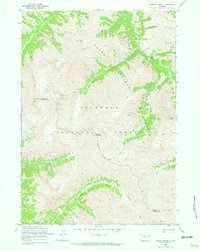
1969 Map of Mount Burwell
USGS Topo · Published 1972About this map
Absaroka Range peaks dominate this high-altitude landscape along the border of Park and Fremont Counties. The survey captures a wilderness at the heart of the Shoshone National Forest, characterized by steep drainages and prominent summits like Mount Burwell and Pyramid Peak. This 1969 field-checked data shows a terrain defined by its water sources, including the headwaters of the Greybull River and the South Fork Wood River. Unlike lower-elevation maps of the era, the absence of established land lines reflects the unsurveyed nature of this high mountain region during the mid-20th century. Movement through this portion of the Absaroka Wilderness is restricted to established paths like the Greybull River Trail and the Wiggins Fork Trail, which cross high points such as Burwell Pass to connect the river valleys.
Find a feature on this map
25 named features on this map. Tap any name to fly to it.
Don’t see what you’re looking for? This feature index may not catch every label — zoom into the map to look around manually.
Map Details
Editions of this 1969 Mount Burwell Map
2 editions found
Other maps of this area

1893 · Ishawooa
USGS Topo · 1:125,000

1895 · Ishawooa
USGS Topo · 1:125,000

1899 · Ishawooa
USGS Topo · 1:125,000

1904 · Kirwin
USGS Topo · 1:125,000

1905 · Younts Peak
USGS Topo · 1:125,000

1906 · Kirwin
USGS Topo · 1:125,000

1907 · Younts Peak
USGS Topo · 1:125,000

1955 · Cody
USGS Topo · 1:250,000

1955 · Thermopolis
USGS Topo · 1:250,000

1956 · Snow Lake
USGS Topo · 1:24,000