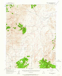
1956 Map of Mount Callaghan
USGS Topo · Published 1963About this map
Mount Callaghan dominates this mid-century high-desert landscape, where ranching and rugged relief define the territory. The map centers on the transition between the Shoshone Range and the sprawling Grass Valley, which is dotted with isolated homesteads and working livestock operations. Several family-named properties like Callaghan Ranch and Grass Valley Ranch are connected by a network of unimproved roads and a jeep trail that navigate the drainages of Skull Creek and Silver Creek. A small Landing Field near the Grass Valley Ranch indicates the scale of travel required in this secluded region during the 1950s.
Find a feature on this map
60 named features on this map. Tap any name to fly to it.
Don’t see what you’re looking for? This feature index may not catch every label — zoom into the map to look around manually.
Map Details
Editions of this 1956 Mount Callaghan Map
3 editions found
Other maps of this area

1926 · Roberts Mountains
USGS Topo · 1:250,000

1929 · Roberts Mountains
USGS Topo · 1:250,000

1955 · Millett
USGS Topo · 1:250,000

1956 · Mount Callaghan
USGS Topo · 1:62,500

1956 · Walti Hot Springs
USGS Topo · 1:62,500

1956 · Hall Creek
USGS Topo · 1:62,500

1956 · Ackerman Canyon
USGS Topo · 1:62,500

1956 · Austin
USGS Topo · 1:62,500

1959 · Millett
USGS Topo · 1:250,000

1960 · Hickison Summit
USGS Topo · 1:62,500