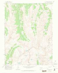
1960 Map of Mount Champion
USGS Topo · Published 1978About this map
The Continental Divide carves a high-altitude boundary through this 1960 field-checked survey, separating the White River National Forest from the San Isabel National Forest. This remote high-country landscape is defined by its industrial remnants and hydrological headwaters. Near the summit of Mt Champion, the Champion Mine and Champion Mill represent the mining activity that once reached these extreme elevations, connected to the valley floor by a dedicated Tramway and Jeep Trail. A network of glacial basins feeds several prominent water systems, including the Fryingpan River and Roaring Fork River. High-elevation lakes like Independence Lake, Lost Man Lake, and the Fryingpan Lakes are positioned among the Williams Mountains, accessible only by a system of Pack Trails that cross high points such as South Fork Pass.
Find a feature on this map
37 named features on this map. Tap any name to fly to it.
Don’t see what you’re looking for? This feature index may not catch every label — zoom into the map to look around manually.
Map Details
Editions of this 1960 Mount Champion Map
4 editions found
Other maps of this area

1889 · Leadville
USGS Topo · 1:125,000

1891 · Leadville
USGS Topo · 1:125,000

1909 · Mount Jackson
USGS Topo · 1:125,000

1911 · Mount Jackson
USGS Topo · 1:125,000

1935 · Mount Elbert
USGS Topo · 1:62,500

1938 · Mount Elbert
USGS Topo · 1:62,500

1939 · Mount Elbert
USGS Topo · 1:62,500

1942 · Leadville
USGS Topo · 1:125,000

1949 · Holy Cross
USGS Topo · 1:62,500

1951 · Holy Cross
USGS Topo · 1:62,500