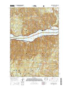
2014 Map of Mount Defiance
USGS Topo · Published 2014About this map
Mount Defiance rises as the dominant peak south of the Columbia River, marking a steep vertical landscape where the Cascade Range meets the river corridor. The map highlights the transit network of the early 21st century, centered on the Lewis and Clark Hwy and the navigation channels of Lake Bonneville, including the Cook Point Range Channel. Small settlements like Cook and the industrial-named Mill sit along the northern banks in Washington, while the Oregon side is defined by the recreation and water management infrastructure of the Mount Hood National Forest. Notable water features such as Drano Lake and the Green Point Lower Reservoir indicate the region's heavy reliance on controlled water resources for both utility and geography. To the north, the terrain transitions into the Gifford Pinchot National Forest, punctuated by prominent heights like Dog Mtn and Augspurger Mtn.
Find a feature on this map
70 named features on this map. Tap any name to fly to it.
Don’t see what you’re looking for? This feature index may not catch every label — zoom into the map to look around manually.
Map Details
Editions of this 2014 Mount Defiance Map
This is the sole edition of this map. No revisions or reprints were ever made.
Other maps of this area

1926 · Hood River
USGS Topo · 1:125,000

1929 · Hood River
USGS Topo · 1:125,000

1953 · The Dalles
USGS Topo · 1:250,000

1956 · The Dalles
USGS Topo · 1:250,000

1957 · The Dalles
USGS Topo · 1:250,000

1957 · Bonneville Dam
USGS Topo · 1:62,500

1957 · Wind River
USGS Topo · 1:62,500

1957 · Willard
USGS Topo · 1:62,500

1957 · Hood River
USGS Topo · 1:62,500
1974 · Parkdale
USGS Topo · 1:24,000