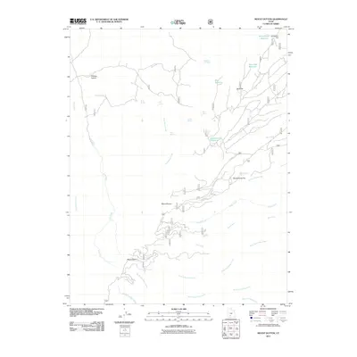
2011 Map of Mount Dutton
USGS Topo · Published 2011About this map
Mount Dutton and Mount Pierson dominate this high-elevation landscape in Garfield County, defining a complex drainage system of creeks and high-mountain flats. The 2011 survey reveals a territory managed for water resources, featuring a series of specialized catchments including Rocky Ford Reservoir, Mule Flat Reservoir, and Jones Corral Reservoir. These water features, alongside numerous named springs such as Dipping Vat Spring and Winnemucca Spring, suggest a history of seasonal grazing and land management. The geography is carved by deep drainages like Callings Hollow and the headwaters of the South Fork Deep Creek, while expansive level areas like Winnemucca Flat and Mule Flat provide distinct breaks in the vertical terrain. This map serves as a precise record of the hydrological network supporting this part of the Utah backcountry.
Find a feature on this map
29 named features on this map. Tap any name to fly to it.
Don’t see what you’re looking for? This feature index may not catch every label — zoom into the map to look around manually.
Map Details
Editions of this 2011 Mount Dutton Map
This is the sole edition of this map. No revisions or reprints were ever made.
Other maps of this area

1885 · Beaver
USGS Topo · 1:250,000

1886 · Kanab
USGS Topo · 1:250,000

1953 · Richfield
USGS Topo · 1:250,000

1953 · Cedar City
USGS Topo · 1:250,000

1958 · Richfield
USGS Topo · 1:250,000

1958 · Cedar City
USGS Topo · 1:250,000

1962 · Cedar City
USGS Topo · 1:250,000

1966 · Bull Rush Peak
USGS Topo · 1:24,000

1966 · Circleville
USGS Topo · 1:24,000
1966 · Junction
USGS Topo · 1:24,000