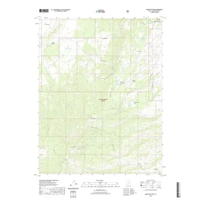
2020 Map of Mount Dutton
USGS Topo · Published 2020About this map
The high Sevier Plateau dominates this portion of the Dixie National Forest, where the prominent peaks of Mt Dutton and Mt Pierson rise above a complex network of canyons and flats. This 2020 topographic record shows a landscape defined by its water management and livestock history, evidenced by features such as Mule Flat Reservoir, Rim Reservoir, and Jones Corral Reservoir. The high-elevation terrain is interconnected by a system of named paths including the Mount Dutton Trail and Mud Spring Trail, which navigate between landmarks like Winnemucca Flat and Dandelion Flat. Numerous water sources, from Dipping Vat Spring to Winnemucca Spring, suggest the historical importance of this area for grazing. Canyons such as Pole Canyon and Callings Hollow carve into the plateau, feeding drainages like N Fork Deep Cr and Forest Cr that flow through the timbered heights.
Find a feature on this map
43 named features on this map. Tap any name to fly to it.
Don’t see what you’re looking for? This feature index may not catch every label — zoom into the map to look around manually.
Map Details
Editions of this 2020 Mount Dutton Map
This is the sole edition of this map. No revisions or reprints were ever made.
Other maps of this area

1885 · Beaver
USGS Topo · 1:250,000

1886 · Kanab
USGS Topo · 1:250,000

1953 · Richfield
USGS Topo · 1:250,000

1953 · Cedar City
USGS Topo · 1:250,000

1958 · Richfield
USGS Topo · 1:250,000

1958 · Cedar City
USGS Topo · 1:250,000

1962 · Cedar City
USGS Topo · 1:250,000

1966 · Bull Rush Peak
USGS Topo · 1:24,000

1966 · Circleville
USGS Topo · 1:24,000
1966 · Junction
USGS Topo · 1:24,000