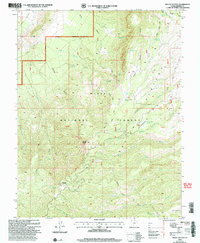
2002 Map of Mount Dutton
USGS Topo · Published 2005About this map
Mount Dutton stands as the dominant peak in this high-altitude section of the Dixie National Forest, marked by the Mount Dutton Communication Site at its summit. The landscape is defined by the massive Sevier Plateau, where deep incisions like Corral Draw and Jones Corral Draw drain the uplands. This area reveals a complex system of water management and natural springs essential for high-country ranching and forest operations. Notable water features include Mule Flat Reservoir and Jones Corral Res, supported by numerous named sources such as Winnemucca Spring and Dipping Vat Spring. The map documents the extensive network of trails and forestry roads that provide access to Mount Pierson and the various cattle-handling features like Corral Draw, reflecting the long-standing use of these public lands for grazing and timber management near the turn of the 21st century.
Find a feature on this map
48 named features on this map. Tap any name to fly to it.
Don’t see what you’re looking for? This feature index may not catch every label — zoom into the map to look around manually.
Map Details
Editions of this 2002 Mount Dutton Map
This is the sole edition of this map. No revisions or reprints were ever made.
Other maps of this area

1885 · Beaver
USGS Topo · 1:250,000

1886 · Kanab
USGS Topo · 1:250,000

1953 · Richfield
USGS Topo · 1:250,000

1953 · Cedar City
USGS Topo · 1:250,000

1958 · Richfield
USGS Topo · 1:250,000

1958 · Cedar City
USGS Topo · 1:250,000

1962 · Cedar City
USGS Topo · 1:250,000

1966 · Bull Rush Peak
USGS Topo · 1:24,000

1966 · Circleville
USGS Topo · 1:24,000
1966 · Junction
USGS Topo · 1:24,000