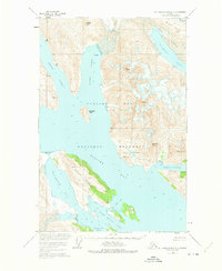
1948 Map of Mount Fairweather D-2
USGS Topo · Published 1975About this map
Glacier Bay National Monument dominates this mid-century topographic record, capturing a landscape defined by retreating ice and advancing waterways. The massive Plateau Glacier and Carroll Glacier are shown at their 1948 and 1972 extents, providing a baseline for the changing geography of the Bruce Hills and the surrounding peaks. Deep glacial fjords like Queen Inlet, Rendu Inlet, and Wachusett Inlet cut through the high terrain, where peaks such as Sentinel Peak and Black Cap Mountain reach above the surrounding ice fields. The central Gilbert Peninsula separates major water bodies, while smaller features like Composite Island and Blue Mouse Cove offer specific points of reference within this dynamic coastal environment. This survey provides detailed soundings and elevations before later decades of further glacial recession altered these shorelines.
Find a feature on this map
24 named features on this map. Tap any name to fly to it.
Don’t see what you’re looking for? This feature index may not catch every label — zoom into the map to look around manually.
Map Details
Editions of this 1948 Mount Fairweather D-2 Map
3 editions found
Other maps of this area

1948 · Mount Fairweather D-1
USGS Topo · 1:63,360

1948 · Mount Fairweather D-2
USGS Topo · 1:63,360

1948 · Mount Fairweather C-1
USGS Topo · 1:63,360

1948 · Mount Fairweather C-2
USGS Topo · 1:63,360

1949 · Mount Fairweather C-1
USGS Topo · 1:63,360

1950 · Mount Fairweather D-2
USGS Topo · 1:63,360

1950 · Mount Fairweather C-2
USGS Topo · 1:63,360

1951 · Mt Fairweather
USGS Topo · 1:250,000

1952 · Skagway
USGS Topo · 1:250,000

1954 · Mount Fairweather D-1
USGS Topo · 1:63,360