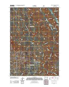
2011 Map of Mount Fanny
USGS Topo · Published 2011About this map
Mount Fanny anchors this high-elevation landscape in Union County, where the headwaters of the Little Minam River and Minam River carve through the Wallowa Mountains. The map highlights a wilderness-oriented economy centered on remote outposts like Minam Lodge and Reds Horse Ranch, both of which are supported by private mountain landing strips including the Minam Lodge Airstrip. This network of backcountry access is further evidenced by several established camps, such as Indian Creek Camp and Moss Springs Horse Camp, located near the start of numerous forest trails. Notable terrain features like Whiskey Flat and Horseshoe Basin sit among a complex system of springs and creeks, including Mount Fanny Spring and Lucky Spring. In the lower elevations, the Elmer Ditch and Mcneill RD indicate the transition from the high peaks toward the managed forest and agricultural lands of the surrounding valley.
Find a feature on this map
38 named features on this map. Tap any name to fly to it.
Don’t see what you’re looking for? This feature index may not catch every label — zoom into the map to look around manually.
Map Details
Editions of this 2011 Mount Fanny Map
This is the sole edition of this map. No revisions or reprints were ever made.
Other maps of this area

1906 · Telocaset
USGS Topo · 1:125,000

1955 · Grangeville
USGS Topo · 1:250,000

1959 · Grangeville
USGS Topo · 1:250,000

1965 · China Cap
USGS Topo · 1:24,000

1965 · Fox Point
USGS Topo · 1:24,000

1965 · Union
USGS Topo · 1:24,000

1965 · Cove
USGS Topo · 1:24,000
1965 · Gasset Bluff
USGS Topo · 1:24,000
1965 · Mount Moriah
USGS Topo · 1:24,000

1965 · Little Catherine Creek
USGS Topo · 1:24,000