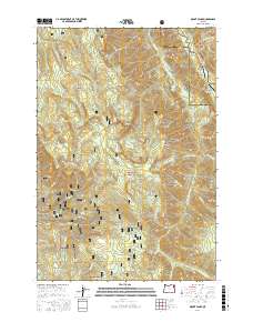
2017 Map of Mount Fanny
USGS Topo · Published 2017About this map
Mount Fanny anchors this high-elevation landscape in eastern Oregon, where the boundaries of the Wallowa National Forest and Whitman National Forest meet. The terrain is defined by deep drainages and ridges, notably the Minam River and the Little Minam River which converge near the Union and Wallowa County line. The presence of the Minam Lodge Airport and Reds Wallowa Horse Ranch Airport indicates the region's reliance on wilderness aviation for access to remote interior points. Human impact is sparse but visible through hydraulic features like the Elmer Ditch and a network of named springs, including Lucky Spring and Lodgepole Spring, which support the seasonal grazing and forest management history of the area. Distinctive landmarks such as Backbone Ridge and Whiskey Flat provide essential geographic context for those tracing land use in this section of the Blue Mountains.
Find a feature on this map
54 named features on this map. Tap any name to fly to it.
Don’t see what you’re looking for? This feature index may not catch every label — zoom into the map to look around manually.
Map Details
Editions of this 2017 Mount Fanny Map
This is the sole edition of this map. No revisions or reprints were ever made.
Other maps of this area

1906 · Telocaset
USGS Topo · 1:125,000

1955 · Grangeville
USGS Topo · 1:250,000

1959 · Grangeville
USGS Topo · 1:250,000

1965 · China Cap
USGS Topo · 1:24,000

1965 · Fox Point
USGS Topo · 1:24,000

1965 · Union
USGS Topo · 1:24,000

1965 · Cove
USGS Topo · 1:24,000
1965 · Gasset Bluff
USGS Topo · 1:24,000
1965 · Mount Moriah
USGS Topo · 1:24,000

1965 · Little Catherine Creek
USGS Topo · 1:24,000