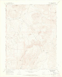
1965 Map of Mount Guero
USGS Topo · Published 1968About this map
Gunnison National Forest dominates this mid-1960s survey, revealing a high-altitude landscape defined by steep drainages and essential water management. The area is intersected by the boundaries of Delta, Gunnison, and Montrose counties, where isolated features like the Hawks-Nest Ranch and a network of irrigation works, including Virginia Ditch and Grand View Ditch, point to the region's agricultural and ranching history.
Find a feature on this map
36 named features on this map. Tap any name to fly to it.
Don’t see what you’re looking for? This feature index may not catch every label — zoom into the map to look around manually.
Map Details
Editions of this 1965 Mount Guero Map
4 editions found

Other maps of this area

1938 · Mt. Gunnison
USGS Topo · 1:48,000

1945 · Mount Gunnison
USGS Topo · 1:62,500

1954 · Little Soap Park
USGS Topo · 1:24,000

1956 · Montrose
USGS Topo · 1:250,000

1957 · Cathedral Peak
USGS Topo · 1:24,000

1957 · X Lazy F Ranch
USGS Topo · 1:24,000

1959 · Montrose
USGS Topo · 1:250,000

1960 · Montrose
USGS Topo · 1:250,000
1964 · West Beckwith Peak
USGS Topo · 1:24,000

1964 · Minnesota Pass
USGS Topo · 1:24,000