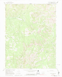
1965 Map of Mount Guero
USGS Topo · Published 1992About this map
Gunnison National Forest dominates this mid-1960s landscape, where complex mountain hydrology is managed through a network of high-altitude irrigation infrastructure. The map detail highlights the Saddle Mountain Highline Ditch, Virginia Ditch, and Grand View Ditch, which redirect snowmelt from the upper drainages to lower-elevation uses. These human-made channels cut across the steep drainages of Virginia Creek and Clear Fork, demonstrating the vital role of water rights in this part of the Colorado high country.
Find a feature on this map
38 named features on this map. Tap any name to fly to it.
Don’t see what you’re looking for? This feature index may not catch every label — zoom into the map to look around manually.
Map Details
Editions of this 1965 Mount Guero Map
4 editions found

Other maps of this area

1938 · Mt. Gunnison
USGS Topo · 1:48,000

1945 · Mount Gunnison
USGS Topo · 1:62,500

1954 · Little Soap Park
USGS Topo · 1:24,000

1956 · Montrose
USGS Topo · 1:250,000

1957 · Cathedral Peak
USGS Topo · 1:24,000

1957 · X Lazy F Ranch
USGS Topo · 1:24,000

1959 · Montrose
USGS Topo · 1:250,000

1960 · Montrose
USGS Topo · 1:250,000
1964 · West Beckwith Peak
USGS Topo · 1:24,000

1964 · Minnesota Pass
USGS Topo · 1:24,000