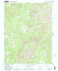
1965 Map of Mount Guero
USGS Topo · Published 1992About this map
Gunnison National Forest dominates this mid-century landscape, where a complex network of ridges and watercourses defines the boundary between Delta, Gunnison, and Montrose counties. Elevated peaks like Mount Guero and the distinctive Tater Heap overlook a series of drainages, including the South Smith Fork and Curecanti Creek. The presence of Hawks Nest Ranch and several irrigation features such as the Virginia Ditch, Highline Ditch, and Grand View Ditch reveals how early settlers managed water in this high-altitude environment to support local ranching.
Find a feature on this map
39 named features on this map. Tap any name to fly to it.
Don’t see what you’re looking for? This feature index may not catch every label — zoom into the map to look around manually.
Map Details
Editions of this 1965 Mount Guero Map
4 editions found

Other maps of this area

1938 · Mt. Gunnison
USGS Topo · 1:48,000

1945 · Mount Gunnison
USGS Topo · 1:62,500

1954 · Little Soap Park
USGS Topo · 1:24,000

1956 · Montrose
USGS Topo · 1:250,000

1957 · Cathedral Peak
USGS Topo · 1:24,000

1957 · X Lazy F Ranch
USGS Topo · 1:24,000

1959 · Montrose
USGS Topo · 1:250,000

1960 · Montrose
USGS Topo · 1:250,000
1964 · West Beckwith Peak
USGS Topo · 1:24,000

1964 · Minnesota Pass
USGS Topo · 1:24,000