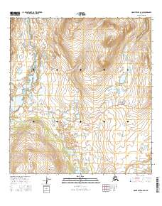
2016 Map of Mount Hayes A-4 SW
USGS Topo · Published 2016About this map
The Denali Highway cuts an east-west path across this subarctic landscape, providing a critical transit corridor through a region dominated by wetlands and alpine terrain. This 2016 survey shows the road as it winds between the foothills and high basins of the Mount Hayes area. The hydrology of the district is defined by a series of significant water bodies, including Little Swede Lake and its larger neighbor, Swede Lake, located in the southern portion of the quadrangle. Further east, the uniquely named Wait-A-Bit Lake sits near the map edge. The drainage of Clear Cr flows through the northern reaches, illustrating the complex network of creeks and marshlands that characterize this remote interior wilderness. The map details the transition from the high-elevation slopes of the Alaska Range down to the lake-studded plains, where the highway remains the primary evidence of human infrastructure.
Find a feature on this map
9 named features on this map. Tap any name to fly to it.
Don’t see what you’re looking for? This feature index may not catch every label — zoom into the map to look around manually.
Map Details
Editions of this 2016 Mount Hayes A-4 SW Map
This is the sole edition of this map. No revisions or reprints were ever made.
Other maps of this area

1949 · Mount Hayes A-4
USGS Topo · 1:63,360

1949 · Mount Hayes A-5
USGS Topo · 1:63,360

1950 · Mount Hayes
USGS Topo · 1:250,000

1950 · Gulkana D-4
USGS Topo · 1:63,360

1951 · Gulkana
USGS Topo · 1:250,000

1951 · Mount Hayes
USGS Topo · 1:250,000

1951 · Gulkana D-5
USGS Topo · 1:63,360

1952 · Gulkana D-4
USGS Topo · 1:63,360

1952 · Mount Hayes A-4
USGS Topo · 1:63,360
1952 · Gulkana D-5
USGS Topo · 1:63,360