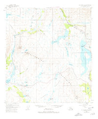
1949 Map of Mount Hayes A-4
USGS Topo · Published 1977About this map
The Amphitheater Mountains and Hungry Hollow dominate this subarctic landscape during a period of significant infrastructure development. The map records the presence of the Trans-Alaska Pipeline (Under Constr) cutting through Isabel Pass, running parallel to the established Richardson Highway. This corridor serves as the primary artery through the high country, connecting the settlement of Paxson in the south to the headwaters of the Delta River.
Find a feature on this map
52 named features on this map. Tap any name to fly to it.
Don’t see what you’re looking for? This feature index may not catch every label — zoom into the map to look around manually.
Map Details
Editions of this 1949 Mount Hayes A-4 Map
5 editions found
Other maps of this area

1949 · Mount Hayes A-4
USGS Topo · 1:63,360

1949 · Gulkana D-3
USGS Topo · 1:63,360

1949 · Mount Hayes A-5
USGS Topo · 1:63,360

1950 · Mount Hayes
USGS Topo · 1:250,000

1950 · Gulkana D-4
USGS Topo · 1:63,360

1950 · Mount Hayes A-3
USGS Topo · 1:63,360

1951 · Gulkana
USGS Topo · 1:250,000

1951 · Mount Hayes
USGS Topo · 1:250,000

1951 · Mt. Hayes B-5
USGS Topo · 1:63,360

1951 · Gulkana D-5
USGS Topo · 1:63,360