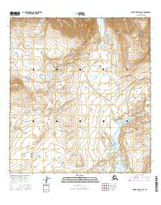
2016 Map of Mount Hayes A-5 SE
USGS Topo · Published 2016About this map
Paxson anchors the southeastern corner of this Alaskan interior landscape, positioned near the junction of vital waterways and road systems. The terrain is characterized by the winding path of the Denali Highway as it traverses the high-altitude topography, crossing Rock Cr multiple times as it moves toward the western reaches of the quadrangle. The hydrography is dominated by the Delta River and the braided channels of the Tangle River, which feed into the complex wetland systems scattered throughout the low-lying basins.
Find a feature on this map
11 named features on this map. Tap any name to fly to it.
Don’t see what you’re looking for? This feature index may not catch every label — zoom into the map to look around manually.
Map Details
Editions of this 2016 Mount Hayes A-5 SE Map
This is the sole edition of this map. No revisions or reprints were ever made.
Other maps of this area

1949 · Mount Hayes A-4
USGS Topo · 1:63,360

1949 · Mount Hayes A-5
USGS Topo · 1:63,360

1950 · Mount Hayes
USGS Topo · 1:250,000

1950 · Gulkana D-4
USGS Topo · 1:63,360

1951 · Gulkana
USGS Topo · 1:250,000

1951 · Mount Hayes
USGS Topo · 1:250,000

1951 · Gulkana D-5
USGS Topo · 1:63,360

1952 · Gulkana D-4
USGS Topo · 1:63,360

1952 · Mount Hayes A-4
USGS Topo · 1:63,360
1952 · Gulkana D-5
USGS Topo · 1:63,360