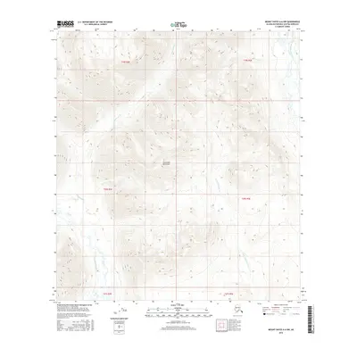
2016 Map of Mount Hayes A-6 NW
USGS Topo · Published 2016About this map
The Clearwater Mountains dominate this high-altitude Alaskan landscape, where the drainage patterns of the West Fork Maclaren River and several glacial-fed creeks define the terrain. This 2016 U.S. Geological Survey representation reveals a wilderness shaped by heavy relief and seasonal water movement, marked by the prominent courses of Clearwater Creek and Little Clearwater Cr. The absence of developed roads or structures emphasizes the remote nature of this portion of the Matanuska-Susitna Borough. Map users can trace the hydrological connections between high ridges and valley floors, following the paths of Coal Cr and Pass Cr through the mountain passes. The map serves as a precise record of the natural topography and hydrologic features before any potential modern development, capturing the raw state of the interior before any human infrastructure was established.
Find a feature on this map
13 named features on this map. Tap any name to fly to it.
Don’t see what you’re looking for? This feature index may not catch every label — zoom into the map to look around manually.
Map Details
Editions of this 2016 Mount Hayes A-6 NW Map
This is the sole edition of this map. No revisions or reprints were ever made.
Other maps of this area

1949 · Healy A-1
USGS Topo · 1:63,360

1950 · Mount Hayes
USGS Topo · 1:250,000

1950 · Healy B-1
USGS Topo · 1:63,360

1950 · Mount Hayes A-6
USGS Topo · 1:63,360

1951 · Healy
USGS Topo · 1:250,000

1951 · Mount Hayes
USGS Topo · 1:250,000

1951 · Mount Hayes B-6
USGS Topo · 1:63,360
1952 · Healy A-1
USGS Topo · 1:63,360

1952 · Healy B-1
USGS Topo · 1:63,360

1952 · Mount Hayes A-6
USGS Topo · 1:63,360